
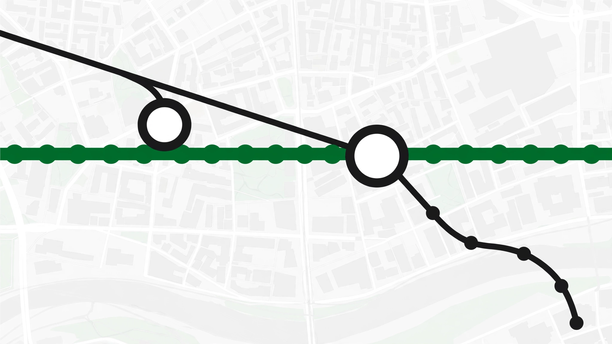
The Dubai Metro map is simpler than it looks: two lines, two interchanges, and one branch split to watch for. The Red Line runs the length of the city from Centrepoint to Expo 2020 / Life Pharmacy; the Green Line loops through Old Dubai from e& to Creek. They meet at just two stations: Union and BurJuman.
This guide walks you through the full 2026 map — every station in order, the Route 2020 branch, interchanges, tram connections, and how to read it like a local.
The Map at a Glance
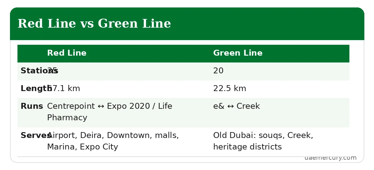
| Red Line | Green Line | |
|---|---|---|
| Colour | Red | Green |
| Stations | 35 | 20 |
| Length | 67.1 km | 22.5 km |
| Runs | Centrepoint ↔ Expo 2020 / Life Pharmacy | e& ↔ Creek |
| Serves | Airport, Deira, Downtown, malls, Marina, Expo City | Old Dubai: souqs, Creek, heritage districts |
Red Line Route: Station by Station
North to south (toward Expo 2020 / Life Pharmacy): Centrepoint → Emirates → Airport Terminal 3 → Airport Terminal 1 → Al Garhoud → City Centre Deira → Al Rigga → Union → BurJuman → ADCB → max → World Trade Centre → Emirates Towers → Financial Centre → Burj Khalifa/Dubai Mall → Business Bay → ONPASSIVE → Equiti → Mall of the Emirates → mashreq → Dubai Internet City → Al Khail → Sobha Realty → DMCC → Jabal Ali — then the split:
- Route 2020 branch: The Gardens → Discovery Gardens → Al Furjan → Jumeirah Golf Estates → Dubai Investment Park → Expo 2020 (terminus)
- Main branch: Ibn Battuta → Energy → Danube → Life Pharmacy (terminus)
Green Line Route: Station by Station
North to south (toward Creek): etisalat by e& → Al Qusais → Dubai Airport Free Zone → Al Nahda → Stadium → Al Qiyadah → Abu Hail → Abu Baker Al Siddique → Salah Al Din → Union → Baniyas Square → Gold Souq → Al Ras → Al Ghubaiba → Sharaf DG → BurJuman → Oud Metha → Dubai Healthcare City → Al Jadaf → Creek (terminus).
The Green Line is the heritage line: Gold Souq and Spice Souq (Gold Souq station), the Creek abras (Al Ghubaiba), Al Fahidi Historical Neighbourhood (Sharaf DG / Al Ghubaiba), and the intercity bus hubs (Union Square, Al Ghubaiba).
The Two Interchanges
| Station | Codes | Notes |
|---|---|---|
| Union | R18 / G20 | Largest underground station in the world (25,000 sqm); long transfer walk — allow extra minutes |
| BurJuman | R19 / G26 | Busiest station in the network; direct mall access |
Transfers happen inside the paid area — follow the interchange signs, no tap-out needed. Use Union for airport ↔ Old Dubai trips and BurJuman for Downtown ↔ Bur Dubai trips.
Tram & Monorail Connections on the Map
- Dubai Tram connects at Sobha Realty (R36) → Dubai Marina tram stop and DMCC (R37) → Jumeirah Lake Towers tram stop, via covered footbridges. Same Nol card works.
- Palm Monorail connects via the tram: ride to Palm Jumeirah tram stop, then a ~10-minute walk to the monorail’s Palm Gateway station.
How to Read the Dubai Metro Map
- Station codes (R11, G24…) run in travel order along each line — higher numbers generally mean further along the line.
- Termini are marked with the line’s end stations; every train’s destination board shows which terminus it’s heading to.
- Number gaps (no R27, R28, R30, R75) are reserved numbers for unbuilt stations — not missing stops.
- Names change: RTA sells naming rights, so the map’s names shift every few years (e.g., Rashidiya → Centrepoint). The codes never change — when in doubt, navigate by code.
Where to Get the Official Map
The most current map lives in the RTA app and the S’hail app (live, with real-time train positions). Station concourses display large printed maps, and every train has a strip map above the doors showing the line with the current station lit. For trip planning with live departures, the apps beat any static map.
Key Journeys on the Map
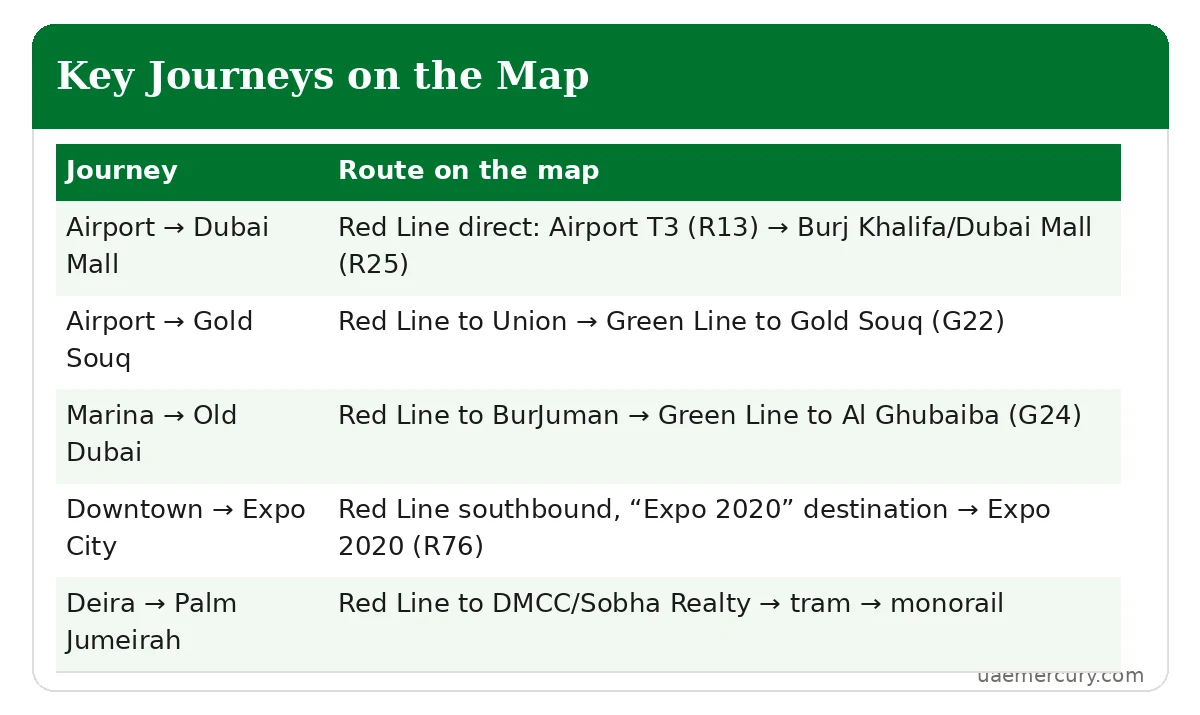
| Journey | Route on the map |
|---|---|
| Airport → Dubai Mall | Red Line direct: Airport T3 (R13) → Burj Khalifa/Dubai Mall (R25) |
| Airport → Gold Souq | Red Line to Union → Green Line to Gold Souq (G22) |
| Marina → Old Dubai | Red Line to BurJuman → Green Line to Al Ghubaiba (G24) |
| Downtown → Expo City | Red Line southbound, “Expo 2020” destination → Expo 2020 (R76) |
| Deira → Palm Jumeirah | Red Line to DMCC/Sobha Realty → tram → Palm Jumeirah tram stop → monorail |
Watch: Dubai Metro Map Video Guide
Last updated: October 2026. Station names follow RTA’s current naming-rights designations; navigate by station code if a name looks unfamiliar.
10 Landmark Stations Worth Finding on the Map
| Station | Code | Why it matters |
|---|---|---|
| Centrepoint | R11 | Red Line northern terminus; 2,700-space park-and-ride |
| Airport Terminal 3 | R13 | DXB Emirates terminal, indoor walkway |
| Union | R18/G20 | Biggest interchange; bus hub |
| BurJuman | R19/G26 | Busiest station (17.8M riders, 2025) |
| Burj Khalifa/Dubai Mall | R25 | Downtown, fountains, mall |
| Mall of the Emirates | R32 | Ski Dubai |
| DMCC | R37 | Tram interchange for Marina & Palm |
| Ibn Battuta | R39 | Themed mall; Abu Dhabi buses |
| Expo 2020 | R76 | Route 2020 terminus; Expo City Dubai |
| Gold Souq | G22 | Deira souqs on the Green Line |
Map Distance vs Real Travel Time
The schematic map compresses distances — here’s what popular journeys actually take:
| Journey | Approx. time* |
|---|---|
| Centrepoint → Expo 2020 (full Red Line) | ~1 hr 14 min |
| Airport T3 → Dubai Mall | ~20 min |
| Union → Mall of the Emirates | ~25 min |
| Gold Souq → Al Ghubaiba (Green Line) | ~15 min |
| DMCC → Dubai Mall | ~20–25 min |
| Jabal Ali → Ibn Battuta | ~5 min |
*Including average waiting time; peak hours add a few minutes.
Using the Map With Live Apps
The static map shows the network; apps show the moment. Pair them:
- RTA S’hail app: official map with live train positions and disruption alerts
- Google Maps / Apple Maps: door-to-door routing with real departure times — best for “which exit?” questions
- Station wayfinding: inside stations, follow the colour-coded line strips on floors and walls rather than the pocket map
Offline & Printable Maps
Going underground kills your signal between stations (station Wi-Fi helps at platforms). Screenshot the official RTA metro map before you travel, or save it offline in Google Maps. RTA also prints pocket maps available at station ticket offices — free, and genuinely useful for first-time visitors.
Red Line Branches on the Map: Don’t Board the Wrong Train
The trickiest part of the map is the Red Line split at Jabal Ali (R38). South of Jabal Ali, the line forks:
- Route 2020 branch (right fork): The Gardens → Discovery Gardens → Al Furjan → Jumeirah Golf Estates → Dubai Investment Park → Expo 2020
- Main branch (left fork): Ibn Battuta → Energy → Danube → Life Pharmacy
Trains display their destination on the front and on platform screens — “Expo 2020” or “Life Pharmacy”. If you’re heading to Expo City and board a Life Pharmacy train, you’ll ride to Jabal Ali and have to double back. Always read the destination, not just the line colour.
Frequently Asked Questions
How many lines are on the Dubai Metro map?
Two: the Red Line (35 stations) and the Green Line (20 stations). A third — the Blue Line — is under construction with a 2029 target.
Where do the Red and Green Lines meet?
At exactly two stations: Union (R18/G20) and BurJuman (R19/G26). Transfer inside the paid area without tapping out.
Why does the Red Line split on the map?
At Jabal Ali (R38) the line divides: one branch runs to Expo 2020 (Route 2020, R70–R76), the other to Life Pharmacy (R39–R42). Check the destination board before boarding.
Which metro line goes to the airport?
The Red Line serves Airport Terminal 3 (R13) and Airport Terminal 1 (R14) directly. Terminal 2 has no metro — use buses from Stadium or Abu Hail on the Green Line.
Is the Dubai Tram on the metro map?
The tram is a separate line connecting at Sobha Realty (R36) and DMCC (R37) via footbridges. Your Nol card works on both.
What do the station codes (R11, G24) mean?
R = Red Line, G = Green Line, followed by a number in travel order. Codes never change even when station names do — navigate by code when unsure.
Where can I download the official Dubai Metro map?
The current map is in the RTA app and S’hail app, with live train positions. Printed maps are displayed in every station concourse and above the doors in each train.
Which line is best for tourists?
The Red Line covers the airport, Dubai Mall/Burj Khalifa, Mall of the Emirates and the Marina. The Green Line covers Old Dubai — souqs, the Creek and heritage districts. Most visitors use both.
How do I get to Expo City Dubai on the map?
Follow the Red Line to Jabal Ali (R38), then the Route 2020 branch (R70–R76) to the Expo 2020 terminus. Board a train showing “Expo 2020” as its destination.
Are there really 55 stations on the Dubai Metro?
Yes — 35 on the Red Line and 20 on the Green Line. Number gaps like R27 or R30 are reserved for unbuilt stations, not missing ones.
Which metro line goes to Dubai Marina?
The Red Line to DMCC (R37) or Sobha Realty (R36), then transfer to the Dubai Tram — same Nol card, a few minutes to the Marina.
How do I get to Palm Jumeirah using the metro map?
Red Line to DMCC, Dubai Tram to Palm Jumeirah tram stop, then the Palm Monorail onto the Palm. Three modes, one journey — see our tram & marine guide.
Is there an official Dubai Metro map app?
The RTA S’hail app is the official option — it includes the network map with live train positions, journey planning and Nol top-up. Google Maps also carries the full network with real-time departures.
Where are the two metro lines’ depots on the map?
The main Rashidiya depot sits beside Centrepoint (R11) at the Red Line’s northern end — it houses up to 64 trains plus the Rail Operations Control Centre. The Green Line’s depot is at Al Qusais, near the etisalat by e& terminus. Neither is a passenger stop, so you won’t find them on the public pocket map.
Keep exploring the Dubai Metro cluster: All Dubai Metro Stations · Dubai Metro Timings · Red Line Guide · Green Line Guide · Fares Guide · Tram & Marine Guide · Nol Card Balance Check
Pingback: Dubai Metro Red Line: Stations & Guide (2026)
Pingback: Union Metro Station Dubai: Interchange Guide (2026)